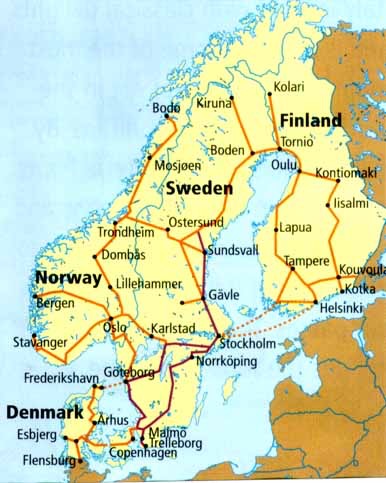
Map of Scandinavia

Map of Scandinavia

Friday, August 7, 2015

Lykesil, Sweden

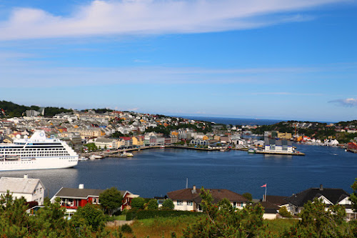
On Friday, August 7th, we docked in Lysekil on the southwestern coast of Sweden. The city was founded some time in the 1500's as a fishing settlement. A doctor established a spa in 1846, and the city then became a destination for summer visitors.

After breakfast we set off on foot to find the town's landmarks. One of them is this church, built in 1901 with a steeple more than 300 ft. tall. Sailors used the church steple as a navigational point of reference.


We climbed up to an observation point and were able to see a marina on the other side of the city.


The city has a pretty little park where some of the locals had their handicrafts out on display.


Later, we walked over to Old Town where we saw these wooden houses from centuries gone by. Many of them had plaques mounted outside telling of the history behind the dwelling.


This is the last port on our cruise. Towmorrow morning we dock in Oslo where we will meet a Norwegian acquaintance from a previous cruise. Tomorrow afternoon we will be flying back to London and then on to the U.S. on Sunday morning. Thanks for taking an interest in the photos from our Norwegian cruise.


Thursday, August 6, 2015

Aalborg, Denmark

Today we sailed into Aalborg on the northern coast of Denmark. The city has Viking roots back to the 5th century, and is relatively new to cruise ship tourism. They were so happy to see us that they set up a Danish hot dog stand within the security gates on the pier and prepared freshly made hot dogs to everyone who wanted them. The Danish claim that while the Americans invented the hamburger, they invented the hot dog.
We took a 3-hour walking tour of the old part of the city. As we saw in Copenhagen, many of their buildings are brightly colored!


This town square, of sorts, serves as a concert venue, and in the winter, they flood it, and it serves as an iceskating rink.

This church was built in two different time periods. The tower on this part clearly shows the year 1779, but in the photo below, you can see the year 1899.


Here's a shot of its interior. It's relatively spartan compared to some of the other cathedrals we've seen further south in Europe.


Sailors who feared for their lives at sea would pray to the Almighty for their safety. If they made it home safely, they would construct a ship to be hung in the local church.


This monument marks the starting point for measuring kilometers in all of Denmark, much like the Puerta del Sol in Madrid. It's 0 km!


This photo shows a monastery dating back to 1431. Initially, it was a poor man's hospital, but later became a monastery/convent where monks and nuns lived. There's a legend that claims that any behavior "beyond talking" between the two groups would be severly punished. In fact, supposedly that type of behavior happened, and the monk was beheaded while the nun was condemned inside a masonry pillar in the basement.
This is the Aalborg City Hall.


This building was built in the year 1624 as you can see in the upper right tower. It was erected by a townsman who wanted to be on the city council, but he could never get elected.

As a way of getting back at the townspeople, he had the masons include faces with their tongues sticking out! Look closely at the top of the masonry work in this photo.


This street housed poor people and the king's soldiers during the mid-16th century. It's really interesting because most people today have taken two homes and combined them together to make a single dwelling to provide more space.

The door on this home shows the provenance up through present day of its owners.


This photo shows an example of the stone sign posts that were used to show that the surrounding area was protected by a certain king. The "R" at the top signifies a certain "kingdom" and the "3 MIL Fra Aalborg" tells how far the post is from Aalborg. They removed the pillars and put them outside a castle in Aalborg.

After our walking tour we went out on our own in search of other interesting sights. Here we saw a city swimming pool, but the pool is actually the river water surrounded by the structure. There are changing rooms and everything off to the side.


Tuesday, August 4, 2015

Geiranger, Norway

We decided to take this Norwegian cruise, in part, so we could visit the fjords. After 16 days out of 20 we finally were able to see some beautiful Norwegian fjords. Geirangerfjord is one of the most beautiful and most visited of all. More than 100 cruise ships visit this slice of Norway during the tourist season from May to September. The town of Geiranger itself only has about 250 permanent residents, but in summer, several hundred thousand tourists descend on the village.

We took a 3-1/2 hour hike up onto a mountainside that proved to be quite strenuous. We learned that Nepalese sherpas built the path using large rocks that were brought in by helicopter. The sherpas positioned and secured the rocks, where needed, with iron and wooden pegs and wedges to make for a well-engineered foot path in order to climb up to the beautiful waterfall.


This is what we woke up to as we cruised through the Geirangerfjord. The little town of Geiranger sits at the back of the fjord.


Here's a shot of the Geirangerfjord from up above on our way to the hike start point. Our ship is off to the right.


This is what the surrounding countryside looks like from up above the fjord.


It was pretty cold during our hike up to the waterfall, but with all the expended energy, we stayed pretty warm.


This waterfall was our intended destinatiion. Once we got there, we discovered that we could actually hike down and behind it as seen below.


Here we are behind the waterfall. If you look closely to the right in this picture, there are more people in our hiking group coming down behind the falls.


In this photo you can see the work of the Nepalese sherpas. Not only did they fit the rocks into a very walkable path, but they also created short footbridges to span the small streams that come down the mountainside.


This photo shows the Geirangerfjord at the back where the actual town of Geiranger is located. There were four cruise ships in the fjord, and the sad part of this is that the MSC giant ship totally dominated the harbor looking from above on the mountain.


On the way out of the Geirangerfjord we sailed past the Seven Sisters Waterfall. We could only count six waterfalls!


Some of the passengers on our trip took a 7-hour bus ride overland between Geiranger and Hellesylt. After we got back from our hike, the ship sailed back down another fjord to pick them up in Hellesylt.


This is the town of Hellesylt, Norway. Its primary landmark is a waterfall right in the middle of town.


This is a shot looking back down the fjord from Hellesylt where we would sail upon leaving the fjord.


Monday, August 3, 2015

North Cape and Kristiansund, Norway

After a day at sea we left Russian waters and arrived at the very norrthernmost city in Norway, Honningsvaag which is very near North Cape. The weather was cloudy, times of heavy fog, and on-and-off drizzle. We talked to a sales clerk in one of the souvenir shops, and she said the weather was typical summer weather. Oh well!!!
There wasn't a lot to see or do in Honningsvaag, so we climbed up to a hill overlooking the harbor. You can see the type of weather we had to deal with for roughly the last two weeks.

We were here on a Saturday, but there still was not a lot of movement in the city. Here you can see a bit of the fjord with the Barents Sea in the upper left corner.


This is the view we had after a day at sea while entering the harbor in Kristiansund, Norway. There was a definite note of enthusiasm among the passengers and crew during breakfast because of the sunny skies.

This is where we tied up at the pier in Kristiansund. If you look closely, you can see all the tires along the pier. We were here from 11:00 until 19:00. The town is actually made up of several islands.


Across from our pier is the island of Old Town or Innlandet. As we pulled into the harbor, someone shot off a cannon three times. If you look closely, you can see the smoke in the right center of this photo. There is a good lookout point where the cannon is located, and we headed to this point after docking.

This bridge connects the island of Innlandet with Kirkelandet where the pier is located. Off in the distance and across the fjord you can see mountains with snow!


As we walked across the bridge (in the photo above) we looked back at our ship and across the harbor to another island, Nordlandet.


Here's a shot taken from up by where the cannons are located. Our ship is docked at Kirkelandet, and we are looking at it from Innlandet.


Here's a shot of Nordlandet taken from the Old Town Innlandet. There didn't seem to be a lot of commercial buildings. Everywhere we looked there were houses and this church.


Finally, here's a video clip taken from the lookout point looking back at the main part of town.


Saturday, July 25, 2015

Alesund, Trondheim, and Hammerfest, Norway

As we entered the fjord that lead us into the harbor at Alesund, Norway, we realized it would be another rainy day. We set out around 11:00 AM in search of the Hop On Hop Off bus stop. At noon we boarded the next bus and stayed on it while touring the town's sites. Alesund is big in the fishing and shipping industries for this area of Norway. We soon reached the top of Mount Aksla where we got out to take some photos. Then it started raining hard, and we realized that going back to the ship on the bus was a good option.

The waterfront in Alesund, Norway.


Another view of the waterfront with Mt. Aksla in the center background.


Yes, it's supposed to be summer here too, but someone forgot to tell Mother Nature to spread a little warmth here in Scandinavia. The temps were in the 50's, and yes, that's snow in the distant mountains.


I like this shot of Alesund from the top of Mt. Aksla because it shows how compact the city center is. The city actually takes up several islands. City center burned down in 1904 leaving more than 10,000 people homeless, and it was rebuiilt in the art nouveau style.


This is a shot looking back into the fjord.


The weather in Trondheim was much the same as in Alesund. This cathedral was built in 1070, and it was a pilgrimage site back in medieval times.


We walked over to this bridge

We crossed this bridge and made our way up to the fortress.


From the fortress we were able to take in wide expanses of the city below and the surrounding countryside.


A shot of the Trondheim marina near the harbor.


Looking back into the fjord from our cabin on the ship.


This is the harbor in Hammerfest, Norway. This city's claim to fame is that it is the northernmost city in the world at 70 degrees north latitude. As you can see, the weather is unrelenting with temperatures in the 50's and on-and-off rain.


The residents of Hammerfest have been up in arms over the herds of reindeer that make their way down into town dropping their feces and urine inside the town. They built barriers up on the hillsides to try to deter the reindeer but with only partial results.


Looking back into the fjord from above Hammerfest.


This is the Meridian Column erected in 1854 to commemorate the first measurement of the earth's exact shape and size. This was accomplished by the King Oscar II. Sweden and Russia also took part. At the bottom of the writing you can see that it sits at 70 degrees north lattitude.